Geolocate

Providence topographic map

Click on the map to display elevation.

About this map

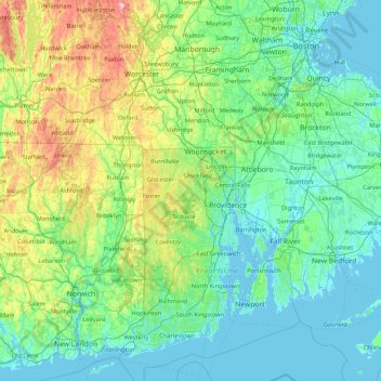
Name: Providence topographic map, elevation, terrain.

Location: Providence, Rhode Island, 02828, USA (41.22774 -72.22148 42.50774 -70.94148)

Average elevation: 285 ft

Minimum elevation: -26 ft

Maximum elevation: 1,893 ft

Gear up for your next adventure:

🔥Plasma Lighters - Windproof lighters that work in any weather condition
📦Gear Storage Bags - Organize and protect outdoor equipment
🪵Folding Camp Saw - Compact saw for wood and campsite work
🥾Hiking Shoes - Durable and comfortable shoes for trail hiking
🍳Camping Cook Set - Complete cookware for outdoor meals

As an Amazon Associate, this site earns from qualifying purchases at no extra cost to you.