
Make a donation
Gear up for your next adventure:
As an Amazon Associate, this site earns from qualifying purchases at no extra cost to you.
Salvador topographic map
Click on the map to display elevation.
Make a donation
Gear up for your next adventure:
As an Amazon Associate, this site earns from qualifying purchases at no extra cost to you.
Salvador
Centralization as a capital, along with Portuguese colonization, were important factors in shaping the profile of the municipality, as were certain geographic characteristics. The construction of the city followed the uneven topography, initially with the formation of two levels—Upper Town (Cidade Alta) and Lower Town (Cidade Baixa)—on a steep escarpment, and later with the conception of valley avenues. With 692,818 square kilometers (267,499 mi2) in area, its emerged territory is peninsular, and the coast is bordered by the Bay of All Saints to the west and the Atlantic Ocean to the east. The Historic Center of Salvador, iconized on the outskirts of Pelourinho, is known for its colonial architecture, with historical monuments dating from the 17th century to the beginning of the 20th century, and was declared a World Heritage Site by UNESCO in 1985. The stage of one of the biggest Carnivals in the world (the biggest street party in the world, according to the Guinness World Records), the integration of the municipality to the UNESCO's Creative Cities Network as the "City of Music", a unique title in the country, added to the international recognition of Salvador's music.
Make a donation
Gear up for your next adventure:
As an Amazon Associate, this site earns from qualifying purchases at no extra cost to you.
About this map
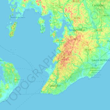
Name: Salvador topographic map, elevation, terrain.
Average elevation: 62 ft
Minimum elevation: -26 ft
Maximum elevation: 472 ft
Make a donation
Gear up for your next adventure:
As an Amazon Associate, this site earns from qualifying purchases at no extra cost to you.
Other topographic maps
Click on a map to view its topography, its elevation and its terrain.
Costa do Sauípe
Brazil > Bahia > Região Metropolitana de Salvador > Mata de São João
Average elevation: 33 ft
Praia do Forte
Brazil > Bahia > Região Metropolitana de Salvador > Mata de São João
Average elevation: 16 ft