
Trois Mares les Hauts topographic map
Interactive map
Click on the map to display elevation.
About this map
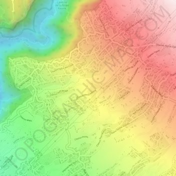
Name: Trois Mares les Hauts topographic map, elevation, terrain.
Average elevation: 2,208 ft
Minimum elevation: 1,020 ft
Maximum elevation: 3,209 ft
Other topographic maps
Click on a map to view its topography, its elevation and its terrain.
Pont D'Yves
France > La Réunion > Le Tampon > Bras de Pontho
Pont D'Yves, Bras de Pontho, Le Tampon, Saint-Pierre, La Réunion, 97414, France
Average elevation: 2,349 ft