
Muhr am See topographic map
Interactive map
Click on the map to display elevation.
About this map
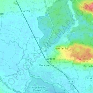
Name: Muhr am See topographic map, elevation, terrain.
Average elevation: 1,388 ft
Minimum elevation: 1,355 ft
Maximum elevation: 1,588 ft
Other topographic maps
Click on a map to view its topography, its elevation and its terrain.
Treuchtlingen
Deutschland > Bayern > Landkreis Weißenburg-Gunzenhausen
Treuchtlingen, Landkreis Weißenburg-Gunzenhausen, Bayern, 91757, Deutschland
Average elevation: 1,654 ft
Pleinfeld
Deutschland > Bayern > Landkreis Weißenburg-Gunzenhausen
Pleinfeld, Landkreis Weißenburg-Gunzenhausen, Bayern, 91785, Deutschland
Average elevation: 1,414 ft