
Nassach topographic map
Interactive map
Click on the map to display elevation.
About this map
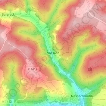
Name: Nassach topographic map, elevation, terrain.
Average elevation: 1,329 ft
Minimum elevation: 935 ft
Maximum elevation: 1,608 ft
Other topographic maps
Click on a map to view its topography, its elevation and its terrain.
Holzhausen
Deutschland > Baden-Württemberg > Landkreis Göppingen > Uhingen
Holzhausen, Uhingen, Vereinbarte Verwaltungsgemeinschaft der Stadt Uhingen, Landkreis Göppingen, Baden-Württemberg, 73066, Deutschland
Average elevation: 1,175 ft