
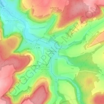
Courcelles-sur-Aujon topographic map
Interactive map
Click on the map to display elevation.
About this map
Name: Courcelles-sur-Aujon topographic map, elevation, terrain.
Average elevation: 1,184 ft
Minimum elevation: 942 ft
Maximum elevation: 1,424 ft
Other topographic maps
Click on a map to view its topography, its elevation and its terrain.
Ériseul
France > Grand Est > Haute-Marne > Saint-Loup-sur-Aujon
Ériseul, Saint-Loup-sur-Aujon, Langres, Haute-Marne, Grand Est, France métropolitaine, 52210, France
Average elevation: 1,207 ft