
Opotiki topographic map
Interactive map
Click on the map to display elevation.
About this map
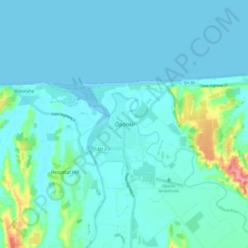
Name: Opotiki topographic map, elevation, terrain.
Average elevation: 46 ft
Minimum elevation: 0 ft
Maximum elevation: 341 ft
Other topographic maps
Click on a map to view its topography, its elevation and its terrain.
Parinui
New Zealand > Bay of Plenty > Ōpōtiki District
Parinui, Ōpōtiki District, Bay of Plenty, 3162, New Zealand
Average elevation: 220 ft
Whitianga
New Zealand > Bay of Plenty > Ōpōtiki District
Whitianga, Ōpōtiki District, Bay of Plenty, 3162, New Zealand
Average elevation: 138 ft
Papamoa
New Zealand > Bay of Plenty > Ōpōtiki District
Papamoa, Ōpōtiki District, Bay of Plenty, New Zealand
Average elevation: 1,785 ft
Ohiwa
New Zealand > Bay of Plenty > Ōpōtiki District
Ohiwa, Ōpōtiki District, Bay of Plenty, 3198, New Zealand
Average elevation: 36 ft
Kaharoa
New Zealand > Bay of Plenty > Ōpōtiki District
Kaharoa, Ōpōtiki District, Bay of Plenty, New Zealand
Average elevation: 2,365 ft