
Radziszów topographic map
Interactive map
Click on the map to display elevation.
About this map
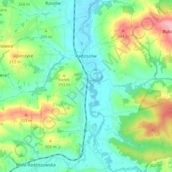
Name: Radziszów topographic map, elevation, terrain.
Average elevation: 860 ft
Minimum elevation: 709 ft
Maximum elevation: 1,201 ft
Other topographic maps
Click on a map to view its topography, its elevation and its terrain.
Werychów
Poland > Lesser Poland Voivodeship > Kraków County > Balice
Werychów, Balice, gmina Zabierzów, Kraków County, Lesser Poland Voivodeship, 31-083, Poland
Average elevation: 781 ft
Bielańsko-Tyniecki Park Krajobrazowy
Poland > Lesser Poland Voivodeship > Kraków County > Krakow
Bielańsko-Tyniecki Park Krajobrazowy, Krakow, gmina Liszki, Kraków County, Lesser Poland Voivodeship, Poland
Average elevation: 784 ft
Podzamcze
Poland > Lesser Poland Voivodeship > Kraków County > Korzkiew > Podzamcze
Podzamcze, Korzkiew, gmina Zielonki, Kraków County, Lesser Poland Voivodeship, Poland
Average elevation: 1,053 ft
Czernichów
Poland > Lesser Poland Voivodeship > Kraków County
Czernichów, gmina Czernichów, Kraków County, Lesser Poland Voivodeship, Poland
Average elevation: 719 ft
Libertów
Poland > Lesser Poland Voivodeship > Kraków County
Libertów, gmina Mogilany, Kraków County, Lesser Poland Voivodeship, 30-444, Poland
Average elevation: 886 ft
Kobylany
Poland > Lesser Poland Voivodeship > Kraków County
Kobylany, gmina Zabierzów, Kraków County, Lesser Poland Voivodeship, Poland
Average elevation: 1,047 ft