
Budingen topographic map
Interactive map
Click on the map to display elevation.
About this map
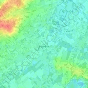
Name: Budingen topographic map, elevation, terrain.
Location: Budingen, Zoutleeuw, Leuven, Vlaams-Brabant, België (50.84612 5.04340 50.88467 5.12009)
Average elevation: 105 ft
Minimum elevation: 66 ft
Maximum elevation: 223 ft
Het dorp ligt in de provincie Vlaams Brabant, aan de samenvloeiing van de Grote en de Kleine Gete op 4,5 km van Zoutleeuw en op 33km van Leuven. Hoogte: 30m aan de kerk en 81m op het hoogste punt.
Other topographic maps
Click on a map to view its topography, its elevation and its terrain.
Zoutleeuw
België > Vlaams-Brabant > Leuven > Zoutleeuw
Zoutleeuw, Leuven, Vlaams-Brabant, Vlaanderen, België
Average elevation: 108 ft
Dormaal
België > Vlaams-Brabant > Leuven > Zoutleeuw
Dormaal, Zoutleeuw, Leuven, Vlaams-Brabant, Vlaanderen, België
Average elevation: 151 ft