
Agrigente topographic map
Interactive map
Click on the map to display elevation.
About this map
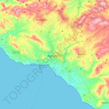
Name: Agrigente topographic map, elevation, terrain.
Location: Agrigente, Sicile, 92100, Italie (37.18968 13.39665 37.44064 13.74862)
Average elevation: 627 ft
Minimum elevation: 0 ft
Maximum elevation: 2,139 ft
Other topographic maps
Click on a map to view its topography, its elevation and its terrain.
Montallegro
Montallegro, Agrigente, Sicile, 92010, Italie
Average elevation: 394 ft
Île de Lampedusa
Italie > Sicile > Agrigente > Lampedusa
Île de Lampedusa, Lampedusa, Lampedusa e Linosa, Agrigente, Sicile, 92031, Italie
Average elevation: 23 ft
Borgo Bonsignore
Italie > Sicile > Agrigente > Ribera
Borgo Bonsignore, Ribera, Agrigente, Sicile, 92016, Italie
Average elevation: 82 ft
Riserva Naturale Orientata Foce del fiume Platani
Italie > Sicile > Agrigente > Ribera > Borgo Bonsignore
Riserva Naturale Orientata Foce del fiume Platani, Strada Provinciale 57, Borgo Bonsignore, Ribera, Agrigente, Sicile, 92016, Italie
Average elevation: 39 ft