
Capelo topographic map
Interactive map
Click on the map to display elevation.
About this map
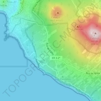
Name: Capelo topographic map, elevation, terrain.
Location: Capelo, Horta, Faial, Açores, 9900-303, Portugal (38.58007 -28.81657 38.59590 -28.78403)
Average elevation: 404 ft
Minimum elevation: 0 ft
Maximum elevation: 1,578 ft
Other topographic maps
Click on a map to view its topography, its elevation and its terrain.
Vulcão dos Capelinhos
Vulcão dos Capelinhos, Capelo, Horta, Faial, Açores, Portugal
Average elevation: 62 ft