
Make a donation
Gear up for your next adventure:
As an Amazon Associate, this site earns from qualifying purchases at no extra cost to you.
Westerwald topographic map
Click on the map to display elevation.
Make a donation
Gear up for your next adventure:
As an Amazon Associate, this site earns from qualifying purchases at no extra cost to you.
Westerwald
The Westerwald (German pronunciation: ; literally 'Western forest') is a low mountain range on the right bank of the river Rhine in the German federal states of Rhineland-Palatinate, Hesse and North Rhine-Westphalia. It is a part of the Rhenish Massif (Rheinisches Schiefergebirge or Rhenish Slate Mountains). Its highest elevation, at 657 m above sea level, is the Fuchskaute in the High Westerwald.
Make a donation
Gear up for your next adventure:
As an Amazon Associate, this site earns from qualifying purchases at no extra cost to you.
About this map
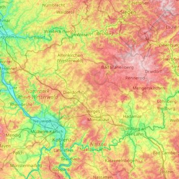
Name: Westerwald topographic map, elevation, terrain.
Location: Westerwald, Rhineland-Palatinate, Germany (50.30275 7.21003 50.81162 8.36354)
Average elevation: 951 ft
Minimum elevation: 171 ft
Maximum elevation: 2,251 ft
Make a donation
Gear up for your next adventure:
As an Amazon Associate, this site earns from qualifying purchases at no extra cost to you.
Other topographic maps
Click on a map to view its topography, its elevation and its terrain.
Leimersdorf
Germany > Rhineland-Palatinate > Landkreis Ahrweiler > Grafschaft
Average elevation: 669 ft
Make a donation
Gear up for your next adventure:
As an Amazon Associate, this site earns from qualifying purchases at no extra cost to you.
Zimmet
Germany > Rhineland-Palatinate > Landkreis Bernkastel-Wittlich > Piesport
Average elevation: 607 ft
Burg Hohlenfels
Germany > Rhineland-Palatinate > Rhein-Lahn-Kreis > Mudershausen
Average elevation: 925 ft
Make a donation
Gear up for your next adventure:
As an Amazon Associate, this site earns from qualifying purchases at no extra cost to you.
Ramstein-Miesenbach
Germany > Rhineland-Palatinate > Landkreis Kaiserslautern > Ramstein-Miesenbach > Ramstein-Miesenbach
Average elevation: 853 ft
Weinfelder Maar
Germany > Rhineland-Palatinate > Landkreis Vulkaneifel > Schalkenmehren
Average elevation: 1,532 ft
Make a donation
Gear up for your next adventure:
As an Amazon Associate, this site earns from qualifying purchases at no extra cost to you.