
San Jerónimo de Tunán topographic map
Interactive map
Click on the map to display elevation.
About this map
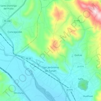
Name: San Jerónimo de Tunán topographic map, elevation, terrain.
Location: San Jerónimo de Tunán, Provincia de Huancayo, Junín, Perú (-11.97567 -75.31278 -11.89206 -75.26544)
Average elevation: 11,145 ft
Minimum elevation: 10,587 ft
Maximum elevation: 13,140 ft
El territorio de este distrito se extiende en 20,99 km² y tiene un altitud de 3 274 metros sobre el nivel del mar.
Other topographic maps
Click on a map to view its topography, its elevation and its terrain.
San Jerónimo de Tunán
Perú > Junín > San Jerónimo de Tunán
San Jerónimo de Tunán, Provincia de Huancayo, Junín, Perú
Average elevation: 10,873 ft