Geolocate

Maracaibo topographic map

Click on the map to display elevation.

About this map
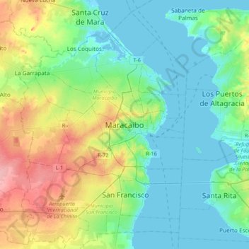
Name: Maracaibo topographic map, elevation, terrain.

Location: Maracaibo, Parroquia Cacique Mara, Municipio Maracaibo, Zulia State, 4012, Venezuela (10.48981 -71.80436 10.80981 -71.48436)

Average elevation: 92 ft

Minimum elevation: -13 ft

Maximum elevation: 331 ft

Other topographic maps

Click on a map to view its topography, its elevation and its terrain.
Gear up for your next adventure:

🧥Men's Rain Shells - Premium waterproof and breathable jackets for mountain weather
🔥Camping Stove - Portable stove for camping and backcountry cooking
🏫Relief Map Kits - Hands-on tools for teaching landforms and elevation
⌚GPS Sports Watch - GPS watch for running, hiking and training
🪑Ultralight Camp Chairs - Portable seating for resting after a long day of mapping

As an Amazon Associate, this site earns from qualifying purchases at no extra cost to you.