
Castor topographic map
Interactive map
Click on the map to display elevation.
About this map
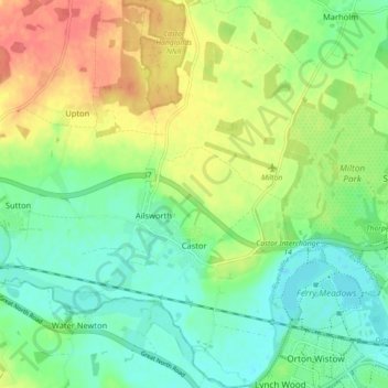
Name: Castor topographic map, elevation, terrain.
Average elevation: 82 ft
Minimum elevation: 10 ft
Maximum elevation: 190 ft
Other topographic maps
Click on a map to view its topography, its elevation and its terrain.
Peterborough
United Kingdom > England > City of Peterborough
Peterborough, City of Peterborough, Cambridgeshire and Peterborough, England, PE1 1XH, United Kingdom
Average elevation: 56 ft
Thorney
United Kingdom > England > City of Peterborough
Thorney, City of Peterborough, Cambridgeshire and Peterborough, England, United Kingdom
Average elevation: 7 ft
Northborough
United Kingdom > England > City of Peterborough
Northborough, City of Peterborough, Cambridgeshire and Peterborough, England, United Kingdom
Average elevation: 26 ft