Geolocate

Marianna topographic map

Click on the map to display elevation.

About this map

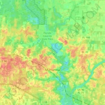
Name: Marianna topographic map, elevation, terrain.

Location: Marianna, Jackson County, Florida, 32447, United States (30.73335 -85.28417 30.85586 -85.16404)

Average elevation: 128 ft

Minimum elevation: 49 ft

Maximum elevation: 220 ft

Jackson County trails, hiking, mountain biking, running and outdoor activities

Other topographic maps

Click on a map to view its topography, its elevation and its terrain.

Compass Lake

United States > Florida > Jackson County

Average elevation: 217 ft

Haynes

United States > Florida > Jackson County > Haynes

Average elevation: 92 ft

Cypress

United States > Florida > Jackson County > Cypress

Average elevation: 135 ft

Gear up for your next adventure:

🗺️Topographic Maps - Detailed topo maps for hiking, exploring and outdoor navigation
🕶️Glacier Sunglasses - Side shields to protect eyes from high-altitude snow glare
🔭Stargazing Telescopes - Perfect for camping in low-light pollution areas shown on maps
Camping Coffee Makers - Enjoy premium coffee at the summit or campsite
Backpacking Tent - Lightweight and durable tent for multi‑day hikes

As an Amazon Associate, this site earns from qualifying purchases at no extra cost to you.