Geolocate

Mursley topographic map

Click on the map to display elevation.

About this map

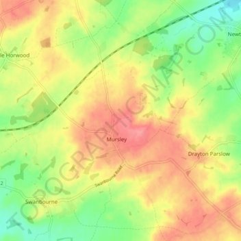
Name: Mursley topographic map, elevation, terrain.

Location: Mursley, Buckinghamshire, England, United Kingdom (51.92992 -0.83759 51.98165 -0.77109)

Average elevation: 420 ft

Minimum elevation: 289 ft

Maximum elevation: 535 ft

Other topographic maps

Click on a map to view its topography, its elevation and its terrain.

Bledlow Ridge

United Kingdom > England > Buckinghamshire

Average elevation: 525 ft

Loudwater

United Kingdom > England > Buckinghamshire

Average elevation: 299 ft

Grove

United Kingdom > England > Buckinghamshire

Average elevation: 308 ft

Burcott

United Kingdom > England > Buckinghamshire > Wing

Average elevation: 407 ft

Tylers Green

United Kingdom > England > Buckinghamshire

Average elevation: 492 ft

Haddington Hill

United Kingdom > England > Buckinghamshire > Halton

Average elevation: 682 ft

Gear up for your next adventure:

📚USA Hiking Guide Books - Top trail guides and map books
🧼Biodegradable Camping Soap - Eco‑friendly soap for outdoor hygiene
GPS Sports Watch - GPS watch for running, hiking and training
🛰️Handheld GPS Units - Professional satellite navigators for precise backcountry mapping
🧭Orienteering Set - Complete compass and map reading kit

As an Amazon Associate, this site earns from qualifying purchases at no extra cost to you.