Geolocate
👉 Easily get elevation data in JSON, GeoTIFF and KML formats using Elevation API
Thank you for supporting this site ❤️
Make a donation

Enstone topographic map

Click on the map to display elevation.

About this map

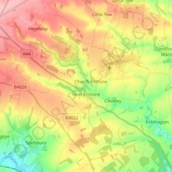
Name: Enstone topographic map, elevation, terrain.

Location: Enstone, West Oxfordshire, Oxfordshire, England, United Kingdom (51.89585 -1.51723 51.94365 -1.38411)

Average elevation: 525 ft

Minimum elevation: 279 ft

Maximum elevation: 764 ft

Other topographic maps

Click on a map to view its topography, its elevation and its terrain.

Windrush

United Kingdom > England > Oxfordshire > West Oxfordshire > Witney

Average elevation: 285 ft

Gear up for your next adventure:

🧭Map Reading Tools - Tools and kits for map navigation
🎒Hydration Pack - Hands‑free water reservoir for long hikes
🕶️GPS Smartphone Mount - Secure mount for phone navigation
🥾Men's Hiking Boots - Durable, waterproof footwear for rugged terrain and steep inclines
🦺Reflective Outdoor Gear - Safety gear for low‑light conditions

As an Amazon Associate, this site earns from qualifying purchases at no extra cost to you.