
Khorixas topographic map
Interactive map
Click on the map to display elevation.
About this map
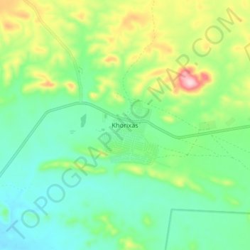
Name: Khorixas topographic map, elevation, terrain.
Location: Khorixas, Kunene Region, Namibia (-20.41384 14.92042 -20.33384 15.00042)
Average elevation: 3,196 ft
Minimum elevation: 2,943 ft
Maximum elevation: 3,770 ft
The regional hospital and some other regional offices are still located in Khorixas, though the capital of Kunene Region is Opuwo. Khorixas has a landing strip nine kilometers east of town parallel to the main road C39. The Runway Numbers are 09/27 and elevation is 3320 feet.