
Make a donation
Gear up for your next adventure:
As an Amazon Associate, this site earns from qualifying purchases at no extra cost to you.
Massingir topographic map
Click on the map to display elevation.
Make a donation
Gear up for your next adventure:
As an Amazon Associate, this site earns from qualifying purchases at no extra cost to you.
About this map
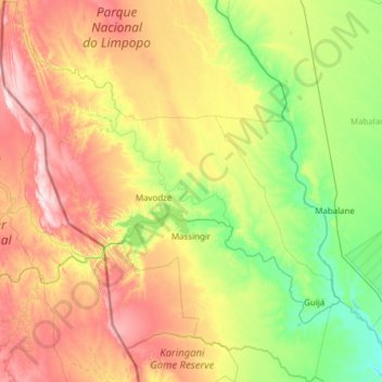
Name: Massingir topographic map, elevation, terrain.
Location: Massingir, Gaza Province, Mozambique (-24.34799 31.55073 -23.22693 32.63990)
Average elevation: 614 ft
Minimum elevation: 121 ft
Maximum elevation: 1,627 ft
Make a donation
Gear up for your next adventure:
As an Amazon Associate, this site earns from qualifying purchases at no extra cost to you.
Other topographic maps
Click on a map to view its topography, its elevation and its terrain.
Xai-Xai
At an elevation of 9.8 m (32 ft), Xai-Xai is located on the Limpopo River, close to the Indian Ocean, and in a wide, fertile plain where rice is grown. It is 200 kilometres (120 mi) from the capital, Maputo, and is 5.2 km (3+1⁄4 mi) from Donguene, 4.0 km (2+1⁄2 mi) from Macandene, 2.8 km (1+3⁄4 mi) from…
Average elevation: 62 ft