Geolocate

Quibdó topographic map

Click on the map to display elevation.

About this map

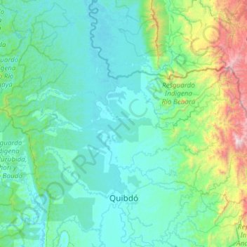
Name: Quibdó topographic map, elevation, terrain.

Location: Quibdó, Atrato, Chocó, RAP Pacífico, Colombia (5.61927 -77.14273 6.34592 -76.16019)

Average elevation: 1,280 ft

Minimum elevation: 26 ft

Maximum elevation: 11,148 ft

Other topographic maps

Click on a map to view its topography, its elevation and its terrain.

Pizarro

Colombia > Chocó > Bajo Baudó (Pizarro)

Average elevation: 49 ft

Juradó

Colombia > Chocó > Juradó > Juradó

Average elevation: 16 ft

Huaca

Colombia > Chocó > Bahía Solano (Mutis)

Average elevation: 154 ft

Docordó

Colombia > Chocó > El Litoral del San Juan

Average elevation: 23 ft

Gear up for your next adventure:

🕶️Glacier Sunglasses - Side shields to protect eyes from high-altitude snow glare
🪶Fire Starter Kit - Reliable fire starter for survival and camping
📚USA Hiking Guide Books - Top trail guides and map books
📌Outdoor GPS Map App - Apps and devices for digital topographic navigation
📱Solar Portable Charger - Solar power bank for charging devices off‑grid

As an Amazon Associate, this site earns from qualifying purchases at no extra cost to you.