Geolocate

薛城镇 topographic map

Interactive map

Click on the map to display elevation.

About this map

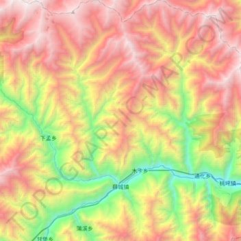
Name: 薛城镇 topographic map, elevation, terrain.

Location: 薛城镇, 理县, 阿坝藏族羌族自治州, 四川省, 中国 (31.48972 103.20209 31.76765 103.36153)

Average elevation: 10,249 ft

Minimum elevation: 4,797 ft

Maximum elevation: 16,001 ft

Other topographic maps

Click on a map to view its topography, its elevation and its terrain.

杂谷脑镇

中国 > 四川省 > 理县

杂谷脑镇, 理县, 阿坝藏族羌族自治州, 四川省, 中国

Average elevation: 10,302 ft

桃坪镇

中国 > 四川省 > 理县

桃坪镇, 理县, 阿坝藏族羌族自治州, 四川省, 中国

Average elevation: 9,393 ft

庄房村

中国 > 四川省 > 理县 > 朴头镇

庄房村, 朴头镇, 理县, 阿坝藏族羌族自治州, 四川省, 中国

Average elevation: 9,580 ft

米亚罗镇

中国 > 四川省 > 理县

米亚罗镇, 理县, 阿坝藏族羌族自治州, 四川省, 中国

Average elevation: 13,150 ft

朴头镇

中国 > 四川省 > 理县

朴头镇, 理县, 阿坝藏族羌族自治州, 四川省, 中国

Average elevation: 11,811 ft

古尔沟镇

中国 > 四川省 > 理县

古尔沟镇, 理县, 阿坝藏族羌族自治州, 四川省, 中国

Average elevation: 12,011 ft

理县

中国 > 四川省 > 理县 > 杂谷脑镇

理县, 杂谷脑镇, 理县, 阿坝藏族羌族自治州, 四川省, 中国

Average elevation: 10,978 ft

毕棚沟

中国 > 四川省 > 理县 > 朴头镇

毕棚沟, 朴头镇, 汶川卧龙特别行政区, 理县, 阿坝藏族羌族自治州, 四川省, 中国

Average elevation: 13,071 ft