
Yamkeshwar topographic map
Interactive map
Click on the map to display elevation.
About this map
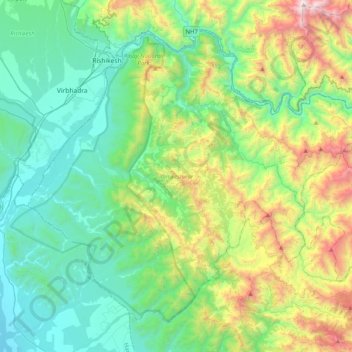
Name: Yamkeshwar topographic map, elevation, terrain.
Location: Yamkeshwar, Pauri Garhwal, Uttarakhand, India (29.85025 78.20168 30.13785 78.60336)
Average elevation: 2,500 ft
Minimum elevation: 820 ft
Maximum elevation: 7,365 ft
Other topographic maps
Click on a map to view its topography, its elevation and its terrain.
Neelkanth Mahadev
India > Uttarakhand > Yamkeshwar
Neelkanth Mahadev, Yamkeshwar, Pauri Garhwal District, Uttarakhand, 249304, India
Average elevation: 2,946 ft
Bhadasi
India > Uttarakhand > Yamkeshwar > Bhadsi
Bhadasi, Bhadsi, Yamkeshwar, Pauri Garhwal, Uttarakhand, 249302, India
Average elevation: 2,979 ft
Devikhal
India > Uttarakhand > Yamkeshwar > Devikhal
Devikhal, Yamkeshwar, Pauri Garhwal, Uttarakhand, 246173, India
Average elevation: 3,727 ft
Elephant Pound Rajaji National park Uttrakhand
India > Uttarakhand > Yamkeshwar
Elephant Pound Rajaji National park Uttrakhand, Yamkeshwar, Pauri Garhwal, Uttarakhand, India
Average elevation: 1,493 ft