
Silkerode topographic map
Interactive map
Click on the map to display elevation.
About this map
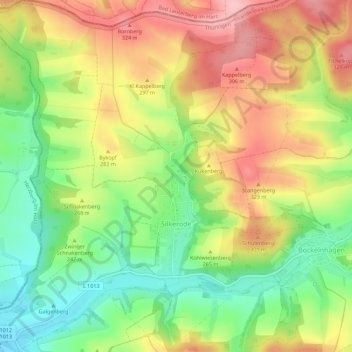
Name: Silkerode topographic map, elevation, terrain.
Average elevation: 833 ft
Minimum elevation: 577 ft
Maximum elevation: 1,112 ft
Other topographic maps
Click on a map to view its topography, its elevation and its terrain.
Werningerode
Deutschland > Thüringen > Sonnenstein > Werningerode
Werningerode, Sonnenstein, Landkreis Eichsfeld, Thüringen, 37345, Deutschland
Average elevation: 968 ft
Iberg
Deutschland > Thüringen > Sonnenstein
Iberg, Sonnenstein, Landkreis Eichsfeld, Thüringen, 37345, Deutschland
Average elevation: 866 ft