
Missoula topographic map
Interactive map
Click on the map to display elevation.
About this map
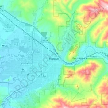
Name: Missoula topographic map, elevation, terrain.
Location: Missoula, Missoula County, Montana, United States (46.79154 -114.12729 46.94995 -113.89732)
Average elevation: 3,848 ft
Minimum elevation: 3,094 ft
Maximum elevation: 6,631 ft
Missoula is located at the western edge of Montana, approximately 45 miles (70 km) from the Idaho border. The city is at an elevation of 3,209 feet (978 m) above sea level, with nearby Mount Sentinel and Mount Jumbo steeply rising to 5,158 feet (1,572 m) and 4,768 feet (1,453 m), respectively. According to the Census Bureau's 2015 figures, the city had a total area of 29.08 square miles (75.3 km2), of which 28.90 square miles (74.9 km2) were land and 0.184 square miles (0.48 km2) were covered by water.
Other topographic maps
Click on a map to view its topography, its elevation and its terrain.
Frenchtown
United States > Montana > Missoula County > Frenchtown
Frenchtown, Missoula County, Montana, United States
Average elevation: 3,343 ft
Seeley Lake
United States > Montana > Missoula County
Seeley Lake, Missoula County, Montana, United States
Average elevation: 4,423 ft
Missoula
United States > Montana > Missoula County > Missoula
Missoula, Missoula County, Montana, 59807, United States
Average elevation: 4,442 ft
De Smet
United States > Montana > Missoula County
De Smet, Missoula County, Montana, 59808, United States
Average elevation: 3,268 ft
Condon
United States > Montana > Missoula County
Condon, Missoula County, Montana, 59826, United States
Average elevation: 3,760 ft
Seeley Lake
United States > Montana > Missoula County
Seeley Lake, Missoula County, Montana, 59868, United States
Average elevation: 4,101 ft
Clinton
United States > Montana > Missoula County
Clinton, Missoula County, Montana, United States
Average elevation: 3,871 ft
Lolo
United States > Montana > Missoula County > Lolo
Lolo, Missoula County, Montana, United States
Average elevation: 3,533 ft
Clearwater Lake
United States > Montana > Missoula County
Clearwater Lake, Missoula County, Montana, United States
Average elevation: 4,892 ft
Lolo Hot Springs
United States > Montana > Missoula County > Lolo Hot Springs
Lolo Hot Springs, Missoula County, Montana, United States
Average elevation: 4,518 ft
Huston
United States > Montana > Missoula County
Huston, Missoula County, Montana, United States
Average elevation: 7,615 ft