Geolocate

Missoula topographic map

Click on the map to display elevation.

About this map

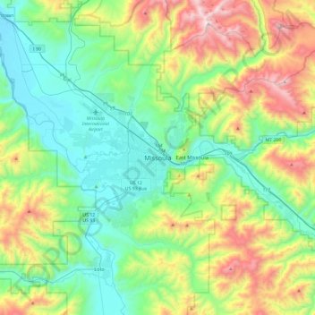
Name: Missoula topographic map, elevation, terrain.

Location: Missoula, Missoula County, Montana, 59807, United States (46.71010 -114.15527 47.03010 -113.83527)

Average elevation: 4,442 ft

Minimum elevation: 3,025 ft

Maximum elevation: 7,884 ft

Missoula County trails, hiking, mountain biking, running and outdoor activities

Gear up for your next adventure:

🔋Solar Power Banks - Keep your GPS and phone charged in remote wilderness areas
🔦Powerful Headlamps - Ultra-bright hands-free lighting for night navigation
🎒Trail Energy Bars - High‑calorie bars for hiking energy
👟Trail Running Shoes - Lightweight shoes for trail runners
🛏️Cold Weather Sleeping Bag - Warm sleeping bag for cold conditions

As an Amazon Associate, this site earns from qualifying purchases at no extra cost to you.