
River Affric topographic map
Interactive map
Click on the map to display elevation.
About this map
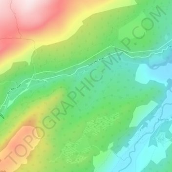
Name: River Affric topographic map, elevation, terrain.
Location: River Affric, Highland, Scotland, IV4 7NB, United Kingdom (57.30585 -4.86745 57.31703 -4.80865)
Average elevation: 873 ft
Minimum elevation: 272 ft
Maximum elevation: 1,893 ft
Other topographic maps
Click on a map to view its topography, its elevation and its terrain.
Kirkwall
United Kingdom > Scotland > Orkney Islands
Kirkwall, Orkney Islands, Scotland, KW15 1DH, United Kingdom
Average elevation: 89 ft
Challoch
United Kingdom > Scotland > Newton Stewart > Challoch
Challoch, Newton Stewart, Dumfries and Galloway, Scotland, DG8 6RB, United Kingdom
Average elevation: 180 ft
Cairngarroch
Cairngarroch, Dumfries and Galloway, Scotland, DG9 9EQ, United Kingdom
Average elevation: 279 ft
Stoneykirk
United Kingdom > Scotland > Stoneykirk
Stoneykirk, Dumfries and Galloway, Scotland, DG9 9DJ, United Kingdom
Average elevation: 125 ft
Newmains
United Kingdom > Scotland > Newmains
Newmains, North Lanarkshire, Scotland, ML2 9AX, United Kingdom
Average elevation: 535 ft
Ayr
United Kingdom > Scotland > Ayr
Ayr, South Ayrshire, Scotland, KA7 1JX, United Kingdom
Average elevation: 52 ft
Edinburgh
United Kingdom > Scotland > Edinburgh
Edinburgh, City of Edinburgh, Scotland, EH1 1BB, United Kingdom
Average elevation: 344 ft
Fishwick
United Kingdom > Scotland > Fishwick
Fishwick, Scottish Borders, Scotland, TD15 1XQ, United Kingdom
Average elevation: 131 ft
Mull
Mull, Argyll and Bute, Scotland, United Kingdom
Average elevation: 400 ft
Alltsigh
United Kingdom > Scotland > Alltsigh
Alltsigh, Highland, Scotland, IV63 7YD, United Kingdom
Average elevation: 620 ft
North Connel
United Kingdom > Scotland > Argyll and Bute
North Connel, Argyll and Bute, Scotland, PA37 1PL, United Kingdom
Average elevation: 62 ft
Ben Nevis
Ben Nevis, Highland, Scotland, United Kingdom
Average elevation: 2,992 ft
Cairnsmore of Fleet
Cairnsmore of Fleet, Dumfries and Galloway, Scotland, DG8 7BL, United Kingdom
Average elevation: 1,604 ft
Muirhouse/Salvesen
United Kingdom > Scotland > Edinburgh
Muirhouse/Salvesen, Edinburgh, City of Edinburgh, Scotland, United Kingdom
Average elevation: 95 ft
Glasgow City
Glasgow City, Scotland, United Kingdom
Average elevation: 210 ft
Waterton
United Kingdom > Scotland > Waterton
Waterton, Aberdeenshire, Scotland, AB41 9QQ, United Kingdom
Average elevation: 105 ft
Grampian Mountains
Grampian Mountains, Highland, Scotland, United Kingdom
Average elevation: 2,543 ft
Scottish Borders
Scottish Borders, Scotland, United Kingdom
Average elevation: 843 ft
Spidean Coire nan Clach (Beinn Eighe)
Spidean Coire nan Clach (Beinn Eighe), Highland, Scotland, United Kingdom
Average elevation: 1,995 ft
Argyll and Bute
Argyll and Bute, Scotland, United Kingdom
Average elevation: 276 ft
Mainland
Mainland, Orkney Islands, Scotland, United Kingdom
Average elevation: 92 ft
Islay
Islay, Argyll and Bute, Scotland, United Kingdom
Average elevation: 174 ft
Lewis and Harris
Lewis and Harris, Na h-Eileanan Siar, Scotland, United Kingdom
Average elevation: 92 ft
Cairngorm Mountains
Cairngorm Mountains, Aberdeenshire, Scotland, United Kingdom
Average elevation: 3,074 ft