
Leedstown topographic map
Interactive map
Click on the map to display elevation.
About this map
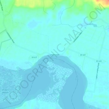
Name: Leedstown topographic map, elevation, terrain.
Location: Leedstown, Westmoreland County, Virginia, United States (38.09152 -77.01858 38.13152 -76.97858)
Average elevation: 20 ft
Minimum elevation: -3 ft
Maximum elevation: 151 ft
Other topographic maps
Click on a map to view its topography, its elevation and its terrain.
Hinnom
United States > Virginia > Westmoreland County
Hinnom, Westmoreland County, Virginia, 22520, United States
Average elevation: 43 ft
Colonial Beach
United States > Virginia > Westmoreland County
Colonial Beach, Westmoreland County, Virginia, United States
Average elevation: 7 ft
Latanes
United States > Virginia > Westmoreland County
Latanes, Westmoreland County, Virginia, 22443, United States
Average elevation: 49 ft
Latanes Pond
United States > Virginia > Westmoreland County > Laurel Grove
Latanes Pond, Laurel Grove, Westmoreland County, Virginia, United States
Average elevation: 30 ft