
Végétation topographic map
Interactive map
Click on the map to display elevation.
About this map
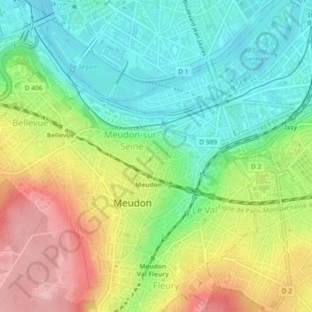
Name: Végétation topographic map, elevation, terrain.
Average elevation: 272 ft
Minimum elevation: 75 ft
Maximum elevation: 568 ft
Other topographic maps
Click on a map to view its topography, its elevation and its terrain.
Étang de Trivaux
France > Île-de-France > Meudon
Étang de Trivaux, Route de l'Étang de Trivaux, Le Parc de Chalais, Meudon-la-Forêt, Meudon, Boulogne-Billancourt, Hauts-de-Seine, Île-de-France, France métropolitaine, 92360, France
Average elevation: 512 ft