
West End topographic map
Interactive map
Click on the map to display elevation.
About this map
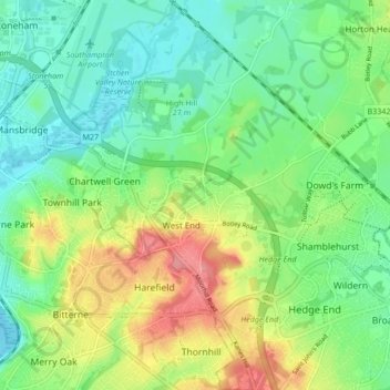
Name: West End topographic map, elevation, terrain.
Location: West End, Eastleigh, Hampshire, England, United Kingdom (50.90433 -1.35900 50.95782 -1.30348)
Average elevation: 102 ft
Minimum elevation: 0 ft
Maximum elevation: 285 ft
Other topographic maps
Click on a map to view its topography, its elevation and its terrain.
West End Copse
United Kingdom > England > Hampshire > Eastleigh > West End
West End Copse, Chartwell Green, West End, Eastleigh, Hampshire, England, United Kingdom
Average elevation: 128 ft
Hatch Grange
United Kingdom > England > Hampshire > Eastleigh > West End
Hatch Grange, West End, Eastleigh, Hampshire, England, United Kingdom
Average elevation: 128 ft
Telegraph Woods
United Kingdom > England > Hampshire > Eastleigh > West End
Telegraph Woods, West End, Eastleigh, Hampshire, South East England, England, United Kingdom
Average elevation: 164 ft