
Port Alfred topographic map
Interactive map
Click on the map to display elevation.
About this map
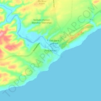
Name: Port Alfred topographic map, elevation, terrain.
Average elevation: 108 ft
Minimum elevation: -10 ft
Maximum elevation: 482 ft
Other topographic maps
Click on a map to view its topography, its elevation and its terrain.
Kenton-on-Sea
South Africa > Eastern Cape > Sarah Baartman District Municipality > Ndlambe Local Municipality
Kenton-on-Sea, Ndlambe Local Municipality, Sarah Baartman District Municipality, Eastern Cape, 6190, South Africa
Average elevation: 72 ft