
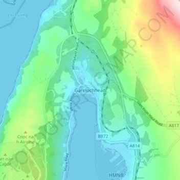
Garelochhead topographic map
Interactive map
Click on the map to display elevation.
About this map
Name: Garelochhead topographic map, elevation, terrain.
Average elevation: 361 ft
Minimum elevation: -3 ft
Maximum elevation: 1,558 ft
Other topographic maps
Click on a map to view its topography, its elevation and its terrain.
Island of Danna
Vereinigtes Königreich > Schottland > Argyll and Bute
Island of Danna, Argyll and Bute, Schottland, Vereinigtes Königreich
Average elevation: 30 ft
Foreland
Vereinigtes Königreich > Schottland > Argyll and Bute
Foreland, Argyll and Bute, Schottland, PA49 7UU, Vereinigtes Königreich
Average elevation: 105 ft
Baile Mòr
Vereinigtes Königreich > Schottland > Argyll and Bute
Baile Mòr, Argyll and Bute, Schottland, PA76 6SJ, Vereinigtes Königreich
Average elevation: 39 ft
Oban
Vereinigtes Königreich > Schottland > Argyll and Bute
Oban, Argyll and Bute, Schottland, PA34 5PZ, Vereinigtes Königreich
Average elevation: 154 ft
Appin
Vereinigtes Königreich > Schottland > Argyll and Bute
Appin, Argyll and Bute, Schottland, PA38 4DB, Vereinigtes Königreich
Average elevation: 305 ft
North Connel
Vereinigtes Königreich > Schottland > Argyll and Bute
North Connel, Argyll and Bute, Schottland, PA37 1PL, Vereinigtes Königreich
Average elevation: 62 ft