
Menderes Mahallesi topographic map
Interactive map
Click on the map to display elevation.
About this map
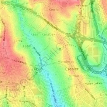
Name: Menderes Mahallesi topographic map, elevation, terrain.
Location: Menderes Mahallesi, Esenler, Istanbul, Marmara Region, Turkey (41.03758 28.87135 41.04540 28.88249)
Average elevation: 256 ft
Minimum elevation: 102 ft
Maximum elevation: 387 ft
Other topographic maps
Click on a map to view its topography, its elevation and its terrain.
Nine Hatun Mahallesi
Nine Hatun Mahallesi, Esenler, Istanbul, Marmara Region, 34200, Turkey
Average elevation: 226 ft