
Mirzo Ulugbek district topographic map
Interactive map
Click on the map to display elevation.
About this map
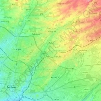
Name: Mirzo Ulugbek district topographic map, elevation, terrain.
Location: Mirzo Ulugbek district, Tashkent, 100000, Uzbekistan (41.30610 69.28015 41.36625 69.41161)
Average elevation: 1,575 ft
Minimum elevation: 1,434 ft
Maximum elevation: 1,762 ft
Other topographic maps
Click on a map to view its topography, its elevation and its terrain.
Yakkasaray district
Yakkasaray district, Tashkent, 100000, Uzbekistan
Average elevation: 1,430 ft
Tashkent
Chilanzar District, Yakkasaroy Tumani, Tashkent, 100000, Uzbekistan
Average elevation: 1,391 ft