
Figueiró da Serra topographic map
Interactive map
Click on the map to display elevation.
About this map
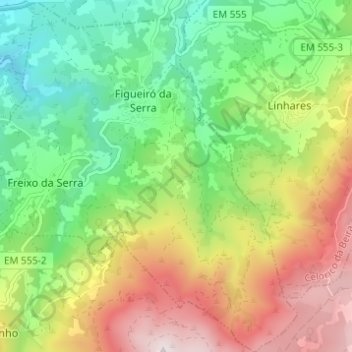
Name: Figueiró da Serra topographic map, elevation, terrain.
Average elevation: 2,533 ft
Minimum elevation: 1,447 ft
Maximum elevation: 4,124 ft
Other topographic maps
Click on a map to view its topography, its elevation and its terrain.
Freixo da Serra
Portugal > Centro > Figueiró da Serra e Freixo da Serra
Freixo da Serra, Figueiró da Serra e Freixo da Serra, Gouveia, Guarda, Serra da Estrela, Centro, Portugal
Average elevation: 2,238 ft