
Kesselspitz topographic map
Interactive map
Click on the map to display elevation.
About this map
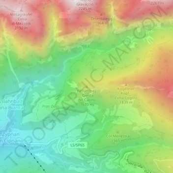
Name: Kesselspitz topographic map, elevation, terrain.
Average elevation: 5,046 ft
Minimum elevation: 3,491 ft
Maximum elevation: 7,234 ft
Other topographic maps
Click on a map to view its topography, its elevation and its terrain.
Grasleitenhütte
Italien > Trentino-Südtirol > Tiers
Grasleitenhütte, 3A, Tiers, Salten-Schlern, Bozen, Trentino-Südtirol, 39050, Italien
Average elevation: 7,792 ft