
Three Fingered Jack topographic map
Interactive map
Click on the map to display elevation.
About this map
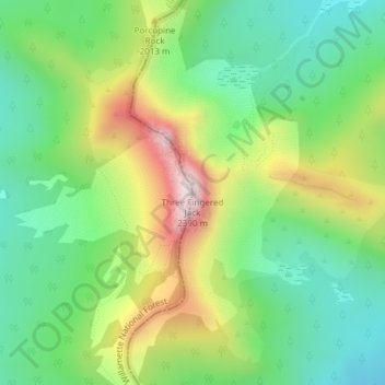
Name: Three Fingered Jack topographic map, elevation, terrain.
Location: Three Fingered Jack, Linn County, Oregon, USA (44.47897 -121.84311 44.47907 -121.84301)
Average elevation: 6,171 ft
Minimum elevation: 5,404 ft
Maximum elevation: 7,500 ft
Other topographic maps
Click on a map to view its topography, its elevation and its terrain.
Crater Lake National Park
USA > Oregon > Rim Village
Crater Lake National Park, Summit Trail, Rim Village, Klamath County, Oregon, 97604, USA
Average elevation: 5,663 ft
Hayden Glacier
Hayden Glacier, climber's trail, Deschutes County, Oregon, USA
Average elevation: 8,340 ft
Renfrew Glacier
Renfrew Glacier, climber's trail, Deschutes County, Oregon, USA
Average elevation: 8,327 ft
Diller Glacier
Diller Glacier, climber's trail, Deschutes County, Oregon, USA
Average elevation: 7,927 ft
Linn Glacier
Linn Glacier, Pacific Crest Trail, Deschutes County, Oregon, USA
Average elevation: 7,740 ft
Prouty Glacier
Prouty Glacier, South Sister Climber Trail #36, Deschutes County, Oregon, USA
Average elevation: 8,494 ft
Reid Glacier
Reid Glacier, Yocum Ridge Trail #771, Clackamas County, Oregon, USA
Average elevation: 7,907 ft
Glisan Glacier
Glisan Glacier, McNeil Point Trail #600M, Hood River County, Oregon, USA
Average elevation: 6,844 ft
Sandy Glacier
Sandy Glacier, Yocum Ridge Trail #771, Clackamas County, Oregon, USA
Average elevation: 7,759 ft
Skinner Glacier
Skinner Glacier, South Sister Climber Trail #36, Deschutes County, Oregon, USA
Average elevation: 8,136 ft
Bend Glacier
Bend Glacier, Broken Top NW Ridge route, Deschutes County, Oregon, USA
Average elevation: 7,710 ft
Milk Creek Glacier
Milk Creek Glacier, Pacific Crest Trail, Jefferson County, Oregon, USA
Average elevation: 8,228 ft
Wallowa Mountains
Wallowa Mountains, Wallowa County, Oregon, USA
Average elevation: 8,120 ft
Ladd Glacier
Ladd Glacier, Barrett Spur, Hood River County, Oregon, USA
Average elevation: 7,562 ft
Coe Glacier
Coe Glacier, Barrett Spur, Hood River County, Oregon, USA
Average elevation: 7,638 ft
Newton Clark Glacier
Newton Clark Glacier, Cooper Spur Trail #600B, Hood River County, Oregon, USA
Average elevation: 8,494 ft
Carver Glacier
Carver Glacier, South Sister Climber Trail #36, Deschutes County, Oregon, USA
Average elevation: 7,825 ft
Zigzag Glacier
Zigzag Glacier, Mountaineer Trail #798, Clackamas County, Oregon, USA
Average elevation: 8,596 ft
Whitewater Glacier
Whitewater Glacier, Pacific Crest Trail, Jefferson County, Oregon, USA
Average elevation: 8,071 ft
Benson Glacier
Benson Glacier, Eagle Cap Summit Trail, Union County, Oregon, USA
Average elevation: 8,166 ft
Mount Tabor
Mount Tabor, Portland, Multnomah County, Oregon, 97215, USA
Average elevation: 282 ft
Hosford-Abernethy
Hosford-Abernethy, Portland, Multnomah County, Oregon, USA
Average elevation: 85 ft
Coalman Glacier
Coalman Glacier, Cooper Spur Trail #600B, Hood River County, Oregon, USA
Average elevation: 8,950 ft
Waldo Glacier
Waldo Glacier, Pacific Crest Trail, Jefferson County, Oregon, USA
Average elevation: 7,717 ft
Langille Glacier
Langille Glacier, Eliot west moraine, Hood River County, Oregon, USA
Average elevation: 7,103 ft
Clark Glacier
Clark Glacier, South Sister Climber Trail #36, Deschutes County, Oregon, USA
Average elevation: 8,458 ft
Lost Creek Glacier
Lost Creek Glacier, South Sister Climber Trail #36, Deschutes County, Oregon, USA
Average elevation: 7,972 ft
Elkhorn Mountains
Elkhorn Mountains, Baker County, Oregon, USA
Average elevation: 7,418 ft
Cove Orchard
USA > Oregon > Cove Orchard
Cove Orchard, Yamhill County, Oregon, 97148, USA
Average elevation: 413 ft
Lathrop Glacier
Lathrop Glacier, Mt. Thielsen climber's trail, Douglas County, Oregon, USA
Average elevation: 7,333 ft
Thayer Glacier
Thayer Glacier, climber's trail, Deschutes County, Oregon, USA
Average elevation: 7,949 ft