
Dunantspitze topographic map
Interactive map
Click on the map to display elevation.
About this map
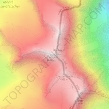
Name: Dunantspitze topographic map, elevation, terrain.
Location: Dunantspitze, Zermatt, Visp, Valais/Wallis, 3920, Switzerland (45.93684 7.86802 45.93694 7.86812)
Average elevation: 13,179 ft
Minimum elevation: 9,652 ft
Maximum elevation: 15,154 ft
Other topographic maps
Click on a map to view its topography, its elevation and its terrain.
Dufourspitze (Monte Rosa)
Switzerland > Valais/Wallis > Zermatt
Dufourspitze (Monte Rosa), Zermatt, Visp, Valais/Wallis, 3920, Switzerland
Average elevation: 13,232 ft
Theodulgletscher
Switzerland > Valais/Wallis > Zermatt
Theodulgletscher, Klein Matterhorn, Trockener Steg, Zermatt, Visp, Valais/Wallis, 3920, Switzerland
Average elevation: 10,591 ft
Pennine Alps
Switzerland > Valais/Wallis > Zermatt
Pennine Alps, Zermatt, Visp, Valais/Wallis, 3920, Switzerland
Average elevation: 12,605 ft
Klein Matterhorn
Switzerland > Valais/Wallis > Zermatt
Klein Matterhorn, Zermatt, Visp, Valais/Wallis, 3920, Switzerland
Average elevation: 11,532 ft
Zumsteinspitze
Switzerland > Valais/Wallis > Zermatt
Zumsteinspitze, Zermatt, Visp, Valais/Wallis, 3920, Switzerland
Average elevation: 13,127 ft
Gornergrat
Switzerland > Valais/Wallis > Zermatt
Gornergrat, Hohtälli, Ze Seewjinen, Zermatt, Visp, Valais/Wallis, 3920, Switzerland
Average elevation: 9,081 ft