
Thank you for supporting this site ❤️
Make a donation
Make a donation
Gear up for your next adventure:
As an Amazon Associate, this site earns from qualifying purchases at no extra cost to you.
Kalaheo topographic map
Click on the map to display elevation.
Thank you for supporting this site ❤️
Make a donation
Make a donation
Gear up for your next adventure:
As an Amazon Associate, this site earns from qualifying purchases at no extra cost to you.
About this map
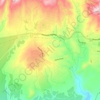
Name: Kalaheo topographic map, elevation, terrain.
Location: Kalaheo, Kauaʻi County, Hawaii, 96741, United States (21.89719 -159.53813 21.93991 -159.51093)
Average elevation: 600 ft
Minimum elevation: 36 ft
Maximum elevation: 1,207 ft
Kauaʻi County trails, hiking, mountain biking, running and outdoor activities
Thank you for supporting this site ❤️
Make a donation
Make a donation
Gear up for your next adventure:
As an Amazon Associate, this site earns from qualifying purchases at no extra cost to you.