
Tepozteco topographic map
Interactive map
Click on the map to display elevation.
About this map
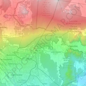
Name: Tepozteco topographic map, elevation, terrain.
Location: Tepozteco, Tepoztlán, Morelos, 62525, México (18.89669 -99.19335 19.08930 -99.01456)
Average elevation: 6,965 ft
Minimum elevation: 4,003 ft
Maximum elevation: 11,325 ft
Other topographic maps
Click on a map to view its topography, its elevation and its terrain.
Santo Domingo Ocotitlán
Santo Domingo Ocotitlán, Tepoztlán, Morelos, 62523, México
Average elevation: 7,379 ft
Santa Catarina
México > Morelos > Tepoztlán > Santa Catarina
Santa Catarina, Tepoztlán, Morelos, 62520, México
Average elevation: 5,400 ft