
Make a donation
Gear up for your next adventure:
As an Amazon Associate, this site earns from qualifying purchases at no extra cost to you.
Sesto Fiorentino topographic map
Click on the map to display elevation.
Make a donation
Gear up for your next adventure:
As an Amazon Associate, this site earns from qualifying purchases at no extra cost to you.
About this map
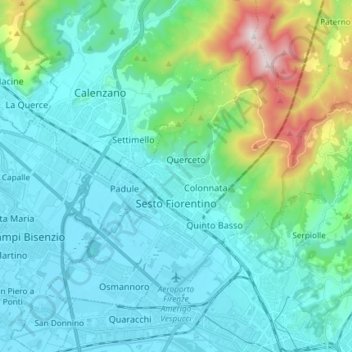
Name: Sesto Fiorentino topographic map, elevation, terrain.
Average elevation: 614 ft
Minimum elevation: 98 ft
Maximum elevation: 3,035 ft
Make a donation
Gear up for your next adventure:
As an Amazon Associate, this site earns from qualifying purchases at no extra cost to you.
Other topographic maps
Click on a map to view its topography, its elevation and its terrain.
Lamole
Italy > Tuscany > Metropolitan City of Florence > Greve in Chianti > Lamole
Average elevation: 1,886 ft
Borro Bologna
Italy > Tuscany > Metropolitan City of Florence > Reggello > San Giovenale
Average elevation: 1,145 ft
Make a donation
Gear up for your next adventure:
As an Amazon Associate, this site earns from qualifying purchases at no extra cost to you.
Castello di Lamole
Italy > Tuscany > Metropolitan City of Florence > Greve in Chianti > Castello di Lamole
Average elevation: 1,929 ft