
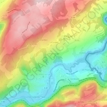
L'Essart Fourgan topographic map
Interactive map
Click on the map to display elevation.
About this map
Name: L'Essart Fourgan topographic map, elevation, terrain.
Average elevation: 2,986 ft
Minimum elevation: 2,441 ft
Maximum elevation: 3,543 ft
Other topographic maps
Click on a map to view its topography, its elevation and its terrain.
Les Combottes
France > Bourgogne-Franche-Comté > Doubs > Villers-le-Lac
Les Combottes, Villers-le-Lac, Pontarlier, Doubs, Bourgogne-Franche-Comté, France métropolitaine, 25130, France
Average elevation: 3,051 ft
Les Pargots
France > Bourgogne-Franche-Comté > Doubs > Villers-le-Lac
Les Pargots, Villers-le-Lac, Pontarlier, Doubs, Bourgogne-Franche-Comté, France métropolitaine, 25130, France
Average elevation: 2,995 ft
Sur la Roche
France > Bourgogne-Franche-Comté > Doubs > Villers-le-Lac
Sur la Roche, Villers-le-Lac, Pontarlier, Doubs, Bourgogne-Franche-Comté, France métropolitaine, 25130, France
Average elevation: 3,406 ft
La Courpée
France > Bourgogne-Franche-Comté > Doubs > Villers-le-Lac
La Courpée, Villers-le-Lac, Pontarlier, Doubs, Bourgogne-Franche-Comté, France métropolitaine, 25130, France
Average elevation: 3,028 ft