Geolocate

Matera topographic map

Click on the map to display elevation.

About this map

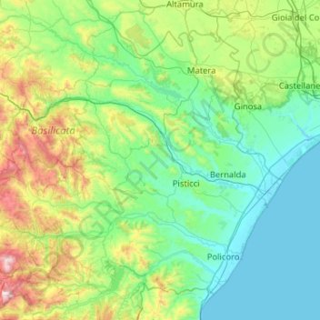
Name: Matera topographic map, elevation, terrain.

Location: Matera, Basilicata, Italy (40.05665 15.94225 40.83858 16.86704)

Average elevation: 1,076 ft

Minimum elevation: -3 ft

Maximum elevation: 6,073 ft

Other topographic maps

Click on a map to view its topography, its elevation and its terrain.

Pollino National Park

Italy > Basilicata

Average elevation: 1,955 ft

Tempa Parese

Italy > Basilicata > Matera > Stigliano

Average elevation: 1,394 ft

Torricelli

Italy > Basilicata > Matera > Ferrandina

Average elevation: 925 ft

Pianelle

Italy > Basilicata > Matera > Montescaglioso > Pianelle

Average elevation: 512 ft

Agri

Italy > Basilicata > Potenza > San Martino d'Agri

Average elevation: 1,611 ft

Gear up for your next adventure:

🔪Outdoor Multitools - Essential survival tools for gear repair and field use
GPS Sports Watch - GPS watch for running, hiking and training
🦶Hiking Gaiters - Keep debris and water out of your boots
🧦Hiking Socks - Comfortable socks to prevent blisters on long hikes
🧢Outdoor Hiking Hat - Sun protection hat for outdoor explorers

As an Amazon Associate, this site earns from qualifying purchases at no extra cost to you.