
Fawley topographic map
Interactive map
Click on the map to display elevation.
About this map
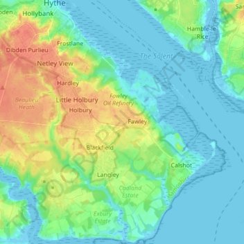
Name: Fawley topographic map, elevation, terrain.
Location: Fawley, New Forest, Hampshire, South East, Engeland, VK (50.78332 -1.40897 50.87062 -1.30127)
Average elevation: 43 ft
Minimum elevation: -16 ft
Maximum elevation: 138 ft
Other topographic maps
Click on a map to view its topography, its elevation and its terrain.
New Forest
VK > Engeland > New Forest
New Forest, Pinkney Lane, Lyndhurst, New Forest, Hampshire, South East, Engeland, SO43 7FE, VK
Average elevation: 112 ft