Geolocate

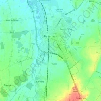
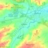
Biggleswade topographic map

Click on the map to display elevation.

Biggleswade

Elevation

Wikipedia (CC-BY-SA 3.0)

About this map

Name: Biggleswade topographic map, elevation, terrain.

Location: Biggleswade, Central Bedfordshire, England, United Kingdom (52.04552 -0.27566 52.11169 -0.21501)

Average elevation: 121 ft

Minimum elevation: 72 ft

Maximum elevation: 259 ft

Other topographic maps

Click on a map to view its topography, its elevation and its terrain.
Flitton

United Kingdom > England > Central Bedfordshire

Average elevation: 230 ft

Greenfield

United Kingdom > England > Central Bedfordshire

Average elevation: 236 ft

Broom

United Kingdom > England > Central Bedfordshire

Average elevation: 121 ft

Fancott

United Kingdom > England > Central Bedfordshire

Average elevation: 387 ft

Dunstable Downs

United Kingdom > England > Central Bedfordshire > Church End

Because of its elevation, Dunstable Downs hosted a station in the shutter telegraph chain which connected the Admiralty in London to its naval ships in the port of Great Yarmouth during the years 1808 to 1814.

Average elevation: 584 ft
Sharpenhoe

United Kingdom > England > Central Bedfordshire

Average elevation: 305 ft

Chaul End

United Kingdom > England > Central Bedfordshire

Average elevation: 522 ft

Campton

United Kingdom > England > Central Bedfordshire

Average elevation: 184 ft

Salford

United Kingdom > England > Central Bedfordshire

Average elevation: 269 ft

Dunton Fen

United Kingdom > England > Central Bedfordshire > Dunton

Average elevation: 121 ft

Ireland

United Kingdom > England > Central Bedfordshire > Southill

Average elevation: 194 ft

Linslade

United Kingdom > England > Central Bedfordshire

Average elevation: 341 ft

Beadlow

United Kingdom > England > Central Bedfordshire > Clophill

Average elevation: 213 ft

Beeston

United Kingdom > England > Central Bedfordshire > Sandy

Average elevation: 102 ft

Hatch

United Kingdom > England > Central Bedfordshire > Northill

Average elevation: 98 ft

Holywell

United Kingdom > England > Central Bedfordshire

Average elevation: 620 ft

Ickwell

United Kingdom > England > Central Bedfordshire

Average elevation: 131 ft

Tebworth

United Kingdom > England > Central Bedfordshire

Average elevation: 400 ft

Hulcote

United Kingdom > England > Central Bedfordshire

Average elevation: 272 ft

Stanford

United Kingdom > England > Central Bedfordshire > Stanford

Average elevation: 138 ft

Ireland

United Kingdom > England > Central Bedfordshire

Average elevation: 194 ft

Hoo Hill

United Kingdom > England > Central Bedfordshire > Clifton

Average elevation: 164 ft

Hatch

United Kingdom > England > Central Bedfordshire > Northill

Average elevation: 98 ft

Gear up for your next adventure:

📶Vehicle Signal Boosters - Improve reception in rural areas while driving to trailheads
🪶Multi‑Purpose Knife - Useful blade for camp and trail
🚁Photography Drones - Capture stunning aerial views of landforms and topography
🎒Trail Energy Bars - High‑calorie bars for hiking energy
🔥Camping Stove - Portable stove for camping and backcountry cooking

As an Amazon Associate, this site earns from qualifying purchases at no extra cost to you.