
Bråviken topographic map
Interactive map
Click on the map to display elevation.
About this map
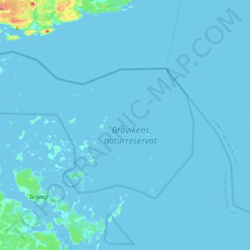
Name: Bråviken topographic map, elevation, terrain.
Average elevation: 7 ft
Minimum elevation: -3 ft
Maximum elevation: 233 ft
Other topographic maps
Click on a map to view its topography, its elevation and its terrain.
Finspång
Sweden > Östergötland County > Finspång
Finspång, Province Östergötland, Östergötland County, Region Götaland, 61230, Sweden
Average elevation: 180 ft
Branden
Branden, Finspång, Province Östergötland, Östergötland County, Region Götaland, Sweden
Average elevation: 276 ft
Åsunden
Åsunden, 134, Kinda, Province Östergötland, Östergötland County, Region Götaland, Sweden
Average elevation: 443 ft