
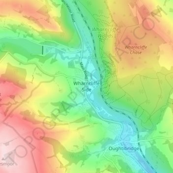
Wharncliffe Side topographic map
Interactive map
Click on the map to display elevation.
About this map
Name: Wharncliffe Side topographic map, elevation, terrain.
Average elevation: 719 ft
Minimum elevation: 276 ft
Maximum elevation: 1,299 ft
Wharcliffe Side is located on the west bank of the River Don, approximately six miles (9.7 km) northwest of Sheffield city centre, and one mile (1.6 km) northwest of Oughtibridge, south of the confluence of the Ewden beck and the River Don. The village is at an elevation of 435 feet (133 m) and the A6102 road passes through the village.[1]
Other topographic maps
Click on a map to view its topography, its elevation and its terrain.
Rails
United Kingdom > England > Sheffield
Rails, Sheffield, South Yorkshire, England, S6 6GF, United Kingdom
Average elevation: 781 ft
Tofts
United Kingdom > England > Sheffield
Tofts, Sheffield, South Yorkshire, England, S6 5SG, United Kingdom
Average elevation: 673 ft
Grenoside
United Kingdom > England > Sheffield > Whitley
Grenoside, Ecclesfield, Whitley, Sheffield, South Yorkshire, England, United Kingdom, Lee Shrogs Wood
Average elevation: 397 ft
Endcliffe Wood
United Kingdom > England > Sheffield
Endcliffe Wood, Endcliffe, Sheffield, South Yorkshire, England, United Kingdom
Average elevation: 522 ft
Wigtwizzle
United Kingdom > England > Sheffield
Wigtwizzle, Bradfield, Sheffield, South Yorkshire, England, S36 4ZA, United Kingdom
Average elevation: 1,010 ft
Cholera Monument
United Kingdom > England > Sheffield
Cholera Monument, Barnes Court, Sheaf Valley, Park Hill, Sheffield, South Yorkshire, England, S2 2UB, United Kingdom
Average elevation: 299 ft
Stocksbridge
United Kingdom > England > Sheffield > Stocksbridge
Stocksbridge, Yorkshire and the Humber, England, S36 2JA, United Kingdom
Average elevation: 784 ft
Margery Hill
United Kingdom > England > Sheffield
Margery Hill, Sheffield, South Yorkshire, England, S33 0BB, United Kingdom
Average elevation: 1,575 ft
Ecclesfield
United Kingdom > England > Sheffield > Whitley
Ecclesfield, Whitley, Sheffield, South Yorkshire, England, United Kingdom, Wheata Wood
Average elevation: 712 ft
Don Valley Bowl
United Kingdom > England > Sheffield
Don Valley Bowl, Sheffield Olympic Legacy Park, Carbrook, Sheffield, South Yorkshire, England, United Kingdom
Average elevation: 177 ft
Moscar Cottages
United Kingdom > England > Sheffield
Moscar Cottages, Sheffield, South Yorkshire, England, S7 2BP, United Kingdom
Average elevation: 476 ft
Stanedge Pole
United Kingdom > England > Sheffield
Stanedge Pole, Sheffield, South Yorkshire Mayoral Combined Authority, England, S32 1DZ, United Kingdom
Average elevation: 1,260 ft
Storrs
United Kingdom > England > Sheffield
Storrs, Sheffield, South Yorkshire Mayoral Combined Authority, England, S6 6GY, United Kingdom
Average elevation: 705 ft
Kelham Island
United Kingdom > England > Sheffield
Kelham Island, Sheffield, Yorkshire and the Humber, England, S3 8DH, United Kingdom
Average elevation: 554 ft
Walkley
United Kingdom > England > Sheffield
Walkley, Sheffield, South Yorkshire Mayoral Combined Authority, England, United Kingdom
Average elevation: 387 ft
Low Holdworth
United Kingdom > England > Sheffield > Dungworth
Low Holdworth, Bradfield, Dungworth, Sheffield, South Yorkshire Mayoral Combined Authority, England, S6 6SQ, United Kingdom
Average elevation: 768 ft
Crookes Valley Park
United Kingdom > England > Sheffield
Crookes Valley Park, Birkendale, Crookesmoor, Sheffield, South Yorkshire, England, United Kingdom
Average elevation: 410 ft
Butterthwaite
United Kingdom > England > Sheffield
Butterthwaite, Ecclesfield, Sheffield, South Yorkshire Mayoral Combined Authority, England, S35 9XJ, United Kingdom
Average elevation: 315 ft
River Sheaf
United Kingdom > England > Sheffield
River Sheaf, Sheffield, Yorkshire and the Humber, England, S17 3LU, United Kingdom
Average elevation: 554 ft
Dungworth
United Kingdom > England > Sheffield
Dungworth, Sheffield, South Yorkshire, England, S6 6HE, United Kingdom
Average elevation: 794 ft
Graves Park
United Kingdom > England > Sheffield
Graves Park, Woodseats, Sheffield, South Yorkshire Mayoral Combined Authority, England, United Kingdom
Average elevation: 571 ft
Endcliffe Park
United Kingdom > England > Sheffield
Endcliffe Park, Endcliffe, Sheffield, Yorkshire and the Humber, England, United Kingdom
Average elevation: 528 ft
River Loxley
United Kingdom > England > Sheffield
River Loxley, Sheffield, Yorkshire and the Humber, England, S6 2FZ, United Kingdom
Average elevation: 322 ft
Ecclesfield CP
United Kingdom > England > Sheffield
Ecclesfield CP, Sheffield, Yorkshire and the Humber, England, United Kingdom
Average elevation: 420 ft
High Bradfield
United Kingdom > England > Sheffield
High Bradfield, Sheffield, South Yorkshire, England, S6 6LG, United Kingdom
Average elevation: 909 ft
Kelham Island
United Kingdom > England > Sheffield
Kelham Island, Kelham Island Community, Kelham Island, Sheffield, Yorkshire and the Humber, England, United Kingdom
Average elevation: 259 ft
Stocksbridge
United Kingdom > England > Sheffield
Stocksbridge, Sheffield, South Yorkshire, England, United Kingdom
Average elevation: 771 ft
Midhopestones
United Kingdom > England > Sheffield > Midhopestones
Midhopestones, Sheffield, Yorkshire and the Humber, England, S36 4GW, United Kingdom
Average elevation: 906 ft
Parkwood Springs
United Kingdom > England > Sheffield
Parkwood Springs, Pitsmoor, Sheffield, South Yorkshire, England, United Kingdom
Average elevation: 308 ft
Devonshire Green
United Kingdom > England > Sheffield
Devonshire Green, Saint George's, Sheffield, Yorkshire and the Humber, England, United Kingdom
Average elevation: 295 ft
Ringinglow
United Kingdom > England > Sheffield
Ringinglow, Sheffield, South Yorkshire Mayoral Combined Authority, England, S11 7TS, United Kingdom
Average elevation: 1,007 ft
River Rivelin
United Kingdom > England > Sheffield
River Rivelin, Sheffield, Yorkshire and the Humber, England, S6 5SP, United Kingdom
Average elevation: 879 ft
Millhouses Park
United Kingdom > England > Sheffield
Millhouses Park, Millhouses, Sheffield, Yorkshire and the Humber, England, S7 2QQ, United Kingdom
Average elevation: 472 ft
Low Bradfield
United Kingdom > England > Sheffield > Low Bradfield
Low Bradfield, Sheffield, Yorkshire and the Humber, England, S6 6LA, United Kingdom
Average elevation: 889 ft
Chapeltown
United Kingdom > England > Sheffield
Chapeltown, Sheffield, South Yorkshire Mayoral Combined Authority, England, S35 2UU, United Kingdom
Average elevation: 371 ft
Whitley
United Kingdom > England > Sheffield
Whitley, Sheffield, South Yorkshire, England, S35 8RP, United Kingdom
Average elevation: 469 ft
Burbage Brook
United Kingdom > England > Sheffield
Burbage Brook, Sheffield, Yorkshire and the Humber, England, S11 7TY, United Kingdom
Average elevation: 1,217 ft
Broomhead Reservoir
United Kingdom > England > Sheffield
Broomhead Reservoir, Stocksbridge, Sheffield, Yorkshire and the Humber, England, United Kingdom
Average elevation: 866 ft
Ewden Height
United Kingdom > England > Sheffield
Ewden Height, Sheffield, Yorkshire and the Humber, England, S36 4GZ, United Kingdom
Average elevation: 1,027 ft
Ecclesall Wood
United Kingdom > England > Sheffield
Ecclesall Wood, Whirlowdale Road, Millhouses, Sheffield, Yorkshire and the Humber, England, S7 2NH, United Kingdom
Average elevation: 531 ft
Oughtibridge
United Kingdom > England > Sheffield
Oughtibridge, Sheffield, South Yorkshire, England, S35 0FL, United Kingdom
Average elevation: 659 ft
Devonshire Quarter
United Kingdom > England > Sheffield
Devonshire Quarter, Sheffield, Yorkshire and the Humber, England, S3 7XG, United Kingdom
Average elevation: 299 ft
Sheaf
United Kingdom > England > Sheffield
Sheaf, Spencer Road, Little Sheffield, Heeley, Sheffield, Yorkshire and the Humber, England, S2 3DS, United Kingdom
Average elevation: 328 ft
Meers Brook
United Kingdom > England > Sheffield
Meers Brook, Sheffield, Yorkshire and the Humber, England, S8 0YD, United Kingdom
Average elevation: 348 ft
Ughill Height
United Kingdom > England > Sheffield
Ughill Height, Sheffield, Yorkshire and the Humber, England, S6 6HY, United Kingdom
Average elevation: 814 ft
Worrall
United Kingdom > England > Sheffield
Worrall, Sheffield, South Yorkshire, England, S35 0PB, United Kingdom
Average elevation: 610 ft
Furnace Hill
United Kingdom > England > Sheffield
Furnace Hill, Sheffield, Yorkshire and the Humber, England, S6 6GN, United Kingdom
Average elevation: 1,096 ft
Abbeyfield Park
United Kingdom > England > Sheffield
Abbeyfield Park, Pitsmoor, Sheffield, South Yorkshire, England, United Kingdom
Average elevation: 285 ft
High Stones
United Kingdom > England > Sheffield
High Stones, Bradfield CP, Sheffield, Yorkshire and the Humber, England, S33 0BB, United Kingdom
Average elevation: 1,486 ft
Bradfield
United Kingdom > England > Sheffield
Bradfield, Sheffield, South Yorkshire, England, United Kingdom
Average elevation: 938 ft