
Paris topographic map
Interactive map
Click on the map to display elevation.
About this map
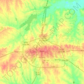
Name: Paris topographic map, elevation, terrain.
Location: Paris, Lamar County, Texas, 75460, United States (33.62063 -95.62794 33.73839 -95.43541)
Average elevation: 522 ft
Minimum elevation: 410 ft
Maximum elevation: 630 ft
Other topographic maps
Click on a map to view its topography, its elevation and its terrain.
Roxton
United States > Texas > Lamar County
Roxton, Lamar County, Texas, 75477, United States
Average elevation: 522 ft
Brookston
United States > Texas > Lamar County
Brookston, Lamar County, Texas, United States
Average elevation: 591 ft
Tigertown
United States > Texas > Lamar County
Tigertown, Lamar County, Texas, United States
Average elevation: 551 ft
Powderly
United States > Texas > Lamar County
Powderly, Lamar County, Texas, 75473, United States
Average elevation: 518 ft
High
United States > Texas > Lamar County
High, Lamar County, Texas, United States
Average elevation: 597 ft
Amherst
United States > Texas > Lamar County > Amherst
Amherst, Lamar County, Texas, United States
Average elevation: 472 ft
Sun Valley
United States > Texas > Lamar County
Sun Valley, Lamar County, Texas, United States
Average elevation: 545 ft
Toco
United States > Texas > Lamar County
Toco, Lamar County, Texas, 75421, United States
Average elevation: 561 ft