Fairfax topographic map
Interactive map
Click on the map to display elevation.
About this map
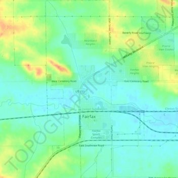
Name: Fairfax topographic map, elevation, terrain.
Location: Fairfax, Linn County, Iowa, United States (41.90552 -91.79421 41.94571 -91.75502)
Average elevation: 784 ft
Minimum elevation: 738 ft
Maximum elevation: 873 ft
Other topographic maps
Click on a map to view its topography, its elevation and its terrain.
Cedar Rapids
United States > Iowa > Linn County
Cedar Rapids, Linn County, Iowa, United States
Average elevation: 804 ft
Springville
United States > Iowa > Linn County
Springville, Linn County, Iowa, 52336, United States
Average elevation: 869 ft
Paris
United States > Iowa > Linn County
Paris, Linn County, Iowa, 52218, United States
Average elevation: 883 ft
Palo
United States > Iowa > Linn County > Palo
Palo, Linn County, Iowa, United States
Average elevation: 751 ft
Central City
United States > Iowa > Linn County
Central City, Linn County, Iowa, United States
Average elevation: 869 ft