
Witry topographic map
Interactive map
Click on the map to display elevation.
About this map
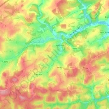
Name: Witry topographic map, elevation, terrain.
Location: Witry, Léglise, Neufchâteau, Luxembourg, Wallonie, Belgique (49.83293 5.56998 49.90092 5.65690)
Average elevation: 1,499 ft
Minimum elevation: 1,276 ft
Maximum elevation: 1,696 ft
Other topographic maps
Click on a map to view its topography, its elevation and its terrain.
Assenois
Belgique > Luxembourg > Neufchâteau > Léglise
Assenois, Léglise, Neufchâteau, Luxembourg, Wallonie, Belgique
Average elevation: 1,378 ft
Bombois
Belgique > Luxembourg > Neufchâteau > Léglise
Bombois, Ebly, Léglise, Neufchâteau, Luxembourg, Wallonie, 6642, Belgique
Average elevation: 1,549 ft
Anlier
Belgique > Luxembourg > Neufchâteau > Léglise
Anlier, Léglise, Neufchâteau, Luxembourg, Wallonie, Belgique
Average elevation: 1,506 ft